Center for Satellite Applications and Research
Featured News
April 18th, 2025
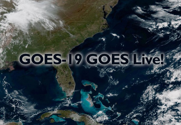
NOAA's GOES-19 satellite now live!
NOAA’s GOES-19 satellite now operational, providing critical new data to forecasters
NOAA’s GOES-19 satellite, the last satellite in theGOES-R Series, began official operations as GOES-East on April 7, 2025.This milestone follows its June 25, 2024 launch and subsequenttesting of its instruments, systems, and data.
This is an historic moment for the GOESprogram, coinciding with its 50th anniversary in 2025. Sincethe first GOES satellite in 1975, NOAA and NASA havepartnered to advance NOAA’s satellite observations from geostationary orbit.
The GOES-19 image stream is now published by the STAR GOESImagery site as successor to GOES-16.
• SeeNOAA’s GOES-19 complete story
Image credits: STAR GOES Imagery site
March 25, 2025
STAR's Christopher Slocum Wins an 8th NOAA David Johnson Award
STAR's winning history spans 27 years
STAR congratulates Christopher Slocum for his 2025 NOAA David Johnson Award.Chris is the 8th STAR Johnson Award winner in the award's 27 year history.
Past STAR winners also include:
2025 - Christopher Slocum2024 - Bill Line2019 - Alejandro Egido2018 - Scott D. Rudlosky2017 - Dan Lindsey2015 - Michael J. Pavolonis2004 - John Knaff1999 - Fuzhong Weng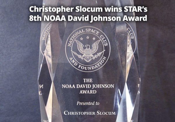
February 18, 2025
TargetingWinter Weather Hazards with New Satellite Data Products
Two new products developed by STAR'sBill Line help NWS forecasters
Blowing snow and freezing sea spray can now both be monitored by NWS forecasters, addressing two different significant winter weather hazards. Blowing snow creates dangerous driving conditions completely distinct from ongoing snowfall; freezing sea spray can capsize or sink ocean vessels. STAR's Bill Line worked to develop these two data products, using VIIRS data for the sea spray product and GOES imager data to observe blowing snow.
photo credits: NWS Des Moines, left, and NOAA Office of Marine and Aircraft Operations, right
• SeeNOAA's complete story
![image on left: Blizzard conditions in rural Iowa [Credit: NWS Des Moines/Mahaska County EMA]; image on right: Ice accumulated on NOAA Ship OSCAR DYSON Photo credits: NOAA Office of Marine and Aircraft Operations](https://img.mxgxt.com/upload/2026/0112/20260112083907_0_kt2r8sbg.jpg)
November 4, 2024
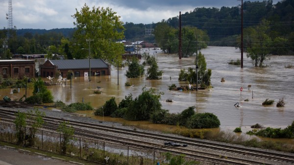
NOAA awards $7.6 million for flooding, extreme precipitation preparedness
Hurricane Helene caused record flooding and damage on September 28, 2024, in Asheville, NC.
On October 29, 2024, the Department of Commerce and NOAA announced $7.6 million in funding for cooperative institutes to transform satellite observations into information communities can use to prepare for and recover from floods and heavy precipitation.
The awards fund work to create street-level maps of potential flooding and inundation, improve models of how water cycles through the nation’s rivers and streams, and develop a new dataset of hourly-precipitation information to help businesses and communities better understand the effects of extreme rainfall.
• Read the full NOAA article.
September 12, 2024
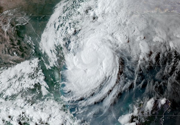
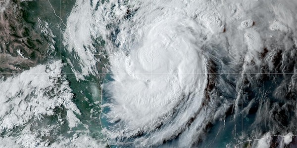
GOES Imagery Tracks Francine
STAR GOES site is a keystorm monitoring resource
On September 8, the NOAA National Hurricane Center (NHC)identified a large low pressure disturbance over the Gulfof Mexico. Now, as named storm Francine, the hurricane dumpedheavy rainfall and produced dangerous winds on Louisianaand Mississippi coasts.
The STAR GOES imagery site producesimages that follow the storm position data from the NHC.GOES storm pages are then referenced by both the NHC andby NOAA's Hurricane Francine pages. The GOES Imagery sitedoes this for every NHC-tracked tropical storm in theAtlantic and eastern Pacific regions.
• NHC Francine forecast & details
• GOES Imagery for Francine
hover over animation to pause
STAR is Shining!
Chris Slocum Wins NOAA David Johnson Award for Tropical Storm Forecasting Work
3/25/2025 - Chris Slocum, a research scientist with NOAA NESDIS’ Center for Satellite Applications and Research (STAR), has been selected as the 2025 winner of NOAA’s David S. Johnson Award. "The David S. Johnson award honors the first Administrator of what became NOAA’s Satellite and Information Service,” said Stephen Volz, Ph.D., Assistant Administrator for NOAA NESDIS. “It recognizes exemplary work from young scientists like Chris Slocum who are using satellite data to help save lives, protect the economy, and benefit society overall."
Slocum is being recognized for developing new operational applications for Advanced Baseline Imager (ABI) and Geostationary Lightning Mapper (GLM) observations from NOAA’s GOES-R Series satellites that provide better guidance for tropical cyclone forecasting.
“NOAA NESDIS has had a rich history of using satellite observations for tropical cyclone monitoring, analysis, and forecasting. The technology on today's generation of GOES satellites provides better insight into changes in convective activity within tropical cyclones,” Slocum said. “Our goal was to couple these improved observing capabilities with innovations in artificial intelligence/machine learning for the most challenging aspects of tropical cyclones forecasting–their formation and rapid intensification.”
To read more about Chris Slocum's work visit his bio.
STAR in the News
Tracking Francine’s Latest Path
September 12, 2024 - Bloomberg News reports:Francine is the third named storm to hit the mainland US this year.The 2024 Atlantic hurricane season got off to a quick start, but hadstalled in recent weeks before Francine. It has now produced six storms,four of which became hurricanes.
STAR's GOES-East geocolor image of the storm is featured.
Read more in the Bloomberg News story.
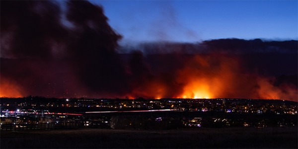
AI and satellite imaging doing early wildfire detection in Colorado
July 30, 2024 - This week the Denver Post reports on a new artificial intelligence program — the Next Generation Fire System — which will help identify wildfires as small as an acre by scanning images taken by weather satellites orbiting about 22,000 miles above the Earth’s surface. NOAA officials say it can process the deluge of data from the satellites — which capture images as frequently as every 30 seconds — and detect heat from fires smaller than a football field. The program then flags potential new fires to a dashboard so humans can check the images and verify the existence of a fire.
While humans are great at detecting a new fire from satellite images, they can’t process the firehose of data as quickly and easily as the AI program, said STAR's Mike Pavolonis, NOAA Satellites’ Wildland Fire Program manager.
Read more in the Denver Post story.
Read more STAR in the News
网址:Center for Satellite Applications and Research https://mxgxt.com/news/view/1942121
相关内容
“birth data and horoscope of 20000 celebrities, horoscopes for astrological research”《海外直订Social Network Mining, Analysis, and Research Trends: Techniques and Applications 社交网络挖掘、分析和研...》 【简介
Rapid Rope Mule Tape: Strength, Versatility, and Ease Combined
Research on the preparation process of dovetail joints in aluminum
Xiaocheng Songs and Notes Network
Thermal stability and wave permeability of high performance SiBN(C) ceramic fibers
Room for Escape: Scribbling Outside the Lines of Template Security
Find research databases
An open
The Architecture of Open Source Applications (Volume 1)Graphite
随便看看
最新实时动态
- 田栩宁多元视角实验大片
- 苏醒携舞团再度燃爆舞台,260711现场高能唱跳!
- 六万字独白撑起整场舞台,陈昊宇以肉身化翼——你就是天使降临现场
- 喝了毒酒的老头竟然还能秒杀几个宫女
- 崔晋百生气心上人在外鬼混,步世子醉酒亲吻他
- 邓超卡点717祝炒米生日快乐,二十一年相伴如约而至
- 具俊晔与大S子女争产官司延期至8月底开庭
- 经纪人李登科称白鹿结束十年演员打工,入局资本赛道
- “我一定是太想念晶晶了”“但你梦里一直喊着紫霞的名字”
- 侯明昊眼神开车萧无衣表白时刻直勾勾凝视谢嘉鱼
热点实时动态
- 128121
- 25460
- 20059
- 19744
- 19495
- 19452
- 19187
- 18756
- 18730
- 18706